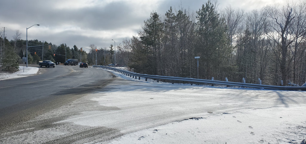
Main image: Councillors have approved the realignment of Shay Rd. As a result of the realignment, this Shay Rd exit at Hanes Rd would eventually be closed, a process which still requires MTO approval. The Hwy 60 – Hanes Rd intersection is in the background.
Representatives for a proposed development on Hanes Rd between Centre St N and Hwy 60 were before Huntsville’s General Committee at its March 24 virtual meeting to seek approval to realign Shay Rd.
According to the proposal, Shay Rd would be extended to Centre St N through the property that lies to the south of Hanes Rd, with the existing Shay Rd exit onto Hanes Rd to eventually be closed.
The property, which comprises 83 acres to the southeast of the Centre St N-Hanes Rd intersection, was acquired by Sanford Investment Corp “a few years ago”, according to representative Ben Jardine, who made the presentation to committee. Former mayor Claude Doughty was also listed as a presenter for the deputation, but did not speak to the proposal during the meeting.
The property, which the developers are calling the Paisley Centre, has had previous approvals for mixed-use residential and commercial developments according to a staff report, but the applicants have not specified their plans for the area.
“…We are not here today with any specific proposals to land use,” said Jardine. “I can say that it’s our intention to develop with the current zoning that’s on the property…currently zoned commercial, that is the intention, but we have no specific designs at this point.”
The road proposal involves a new public road through the property which would connect the existing Shay Road to Centre St N. The new road would also connect with an extension of Ott Drive to the south of Hanes Rd. The existing Shay Rd exit onto Hanes Rd would eventually be closed, pending MTO approvals.
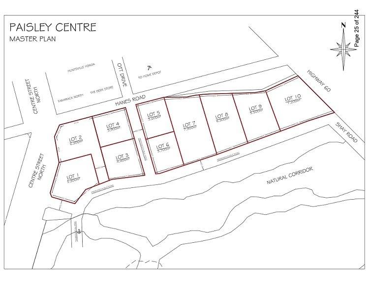
This map shows the proposed road, which would connect the existing Shay Rd with both an extension of Ott Drive (between lots 4 and 5) and Centre St N (next to lot 1). The current Shay Rd exit onto Hanes Rd, which is near Hwy 60 and not depicted on this map, would eventually be closed. (Town of Huntsville)
“The MTO [Ontario Ministry of Transportation] has for a very long time expressed concern about the proximity of Hanes Road, Ott Drive, and Shay Road intersections to Hwy 60,” noted Jardine. “They have for a long time restricted new entrances off of Hanes Road as a result of their concerns and have stipulated public road improvements when reviewing development proposals for the area.”
He added that “the proposed new public road would help to distinguish or transition the commercial and industrial sectors along Hanes from the current and future residential developments to the south. The proposed route is well-matched to the lay of the land and would really follow the natural, gentle gradient of the land.”
Several councillors expressed support for the realignment of Shay Rd and closure of its exit onto Hanes Rd, citing improved safety.
In response to a question from Councillor Dan Armour regarding the need for traffic lights in the area, Brandon Hall, civil engineering technologist for the Town, said that the development still needed to go through the regular planning process and will be subject to traffic impact and pedestrian impact studies, as well as stormwater management and environmental studies.
That process “will lay out what needs to be done, so that may determine any turn lanes on Centre Street, any boulevard removals [on Centre Street], and may trigger a set of stoplights at Hanes Road intersection and Centre Street. All of that is still yet to be determined,” said Hall. “It’s a great opportunity to realign that intersection away from the MTO’s corridor… We are in support of this.”
Hall also noted that “Shay Road won’t be a dead-end street for a certain period of time. That extension from Centre Street will be built and then Shay will still be a full through-road.”
The section of Shay Rd proposed for closure is on MTO land and not owned by the municipality, noted the staff report, and upgrades or alterations are subject to MTO requirements and approvals. The developer will be required to work with the MTO and pay all necessary fees related to the closing and restoration of this section of Shay Rd.
Committee approved the proposed realignment of Shay Rd. Staff have been directed to work with the applicant through the normal planning process and to report back to Council with an agreement outlining the work to be completed by the developer and other associated details.
All resolutions passed at committee must be ratified at the next regular meeting of council.
Don’t miss out on Doppler!
Sign up here to receive our email digest with links to our most recent stories.
Local news in your inbox three times per week!
Click here to support local news
I agree that natural environment should be protected, however, I am concerned about the road structure. Closing Shay seems reasonable BUT making an entrance at Ott Rd is duplicating the same scenario of two intersections close together. Have we lost the opportunity to create a traffic circle at Hanes and Center St. People exiting out of this subdivision could turn tight and take the circle back to town. Much safer than cutting the boulevard and trying to turn south on Center St
This is probably too practical
I wonder who is behind this development? Here we have public funds being spent to increase the value and salability of private lands by putting in new roads and drainage allowing for subdivision into commercial lots. As well as the upkeep into the future. Seems like a sweet deal for the owners of the property. Follow the money.
Just one more piece of Muskoka falling foul to the relentless march of the developers $-driven shovel!
… how sad!.
There are some excellent comments on this proposed development. I too have been admiring these forests, wetlands and wild inhabitants and wondering when the development “shoe” would drop. And so it has.
I am not so naiive to think that the area will dodge the shovel, and I applaud the provision for a natural corridor. As so well stated by other commentators, the area provides ecological and aesthetc values that go far beyond the physical boundary. So I ask of town planners and elected representatives, please demand the best from each other and the developers in all aspects of the project. We are already living with the results of a collective disregard for our natural assets in the form of urban clearcuts, big box skylines and diminished natural flood control.
We’re Huntsville. Sure, “Embrace the Future”. Let’s not beat it to death with a shovel.
This space is pretty rugged and will require a lot of work to make it level and ready to allow the building of a new crop of stores.
It, along with land on the opposite side of highway 60 forms the reservoir and storage buffer for water that flows down past A&W, the site of a major flooding event a few years ago.
Any building in this area, despite what the builders may tell you and despite their efforts at some storm water retention, will ultimately result in increased flow variability in this watershed and the probability of more future flooding events as the climate dishes out a supply of increasingly violent storms.
It seems a shame that the location of this land, will ultimately end up being in the center of the town development with probably a lot more development on the far side of Highway 60 across from Home Depot as time goes on. It would be wonderful to eventually have this area as a semi wild parkland right in the center of the town. A place for habitat, water retention to smooth out creek flow and walking trails for resident recreation, all withing walking distance of most of the main part of town.
The buildings proposed for this site could be easily accommodated in many other more suitable sites for building around the Huntsville area that would not impact the final remaining base for a water shed and remove for all time a significant wildlife habitat and possible future recreational area like this one.
The day will come when we will realize the foolishness of this area for development but somewhat surprisingly it will not be the fault of the developer. Developers are merely opportunists followed a set of rules that often were not well thought out for the longer term. Planning seems to be more reactionary than foresighted and it is always subject to too much economic pressure based on the here and now, rather than the future. You only get one chance to preserve and build upon what nature has provided and once the land is cleared, leveled and covered with buildings, no amount of artistic tree plantings will ever bring this back. One may remember this as we bash the heck out of Main street once again to install new infrastructure and in the process probably remove any living thing that we managed to get to grow over the last 20 years on this street.
In the Commerce park area, environmental considerations were significant, despite not being too obvious at first glance. Small lakes were created and some pockets of wetland and trees were left. Flow control structures were built to help maintain even water flow, but as time goes by these areas and why they are there always seem to suffer. A little fill here, a minor plan amendment there, a bit more parking, maybe an addition to an existing store…. it goes on all the time and suddenly we find that our initial efforts to maintain the balance of a watershed and habitat area have been compromised to the point where they can no longer do the job they were originally designed to do. Remember that even the original design was probably a “minimum” for the environment such that the economic benefits to the developer were maximized as that is the whole purpose of development.
I think Huntsville could have done better , not just for for this chunk of land, but for several others in the area. Forbes Hill and the Highway 60 strip mall come to mind as other examples but I suppose this is “progress” of some sort. I just wonder if it is actually “good” progress for the long term.
I’m so glad to see that I am not alone in feeling heart broken at the thought of losing this beautiful forest. Please can we value more than development of buildings? Can we develop the wild too????
I have long hoped this property would stay a treasured wild space. In the centre of a growing urban area, it should be more than just another parking lot.
Huntsville is surrounded by wild green spaces. The wild green spaces inside Huntsville are very important. How to balance economics and long term well designed green wild spaces. I think it can be done.
While at Petro Canada last night I again felt the loss of that hilltop. What a view but not unless you get past the parking lots!!!
I hope that the town and the developers will allocate a large swath of land in this area to nature. This will not only help with water management and carbon sequestering, it will provide animals and we humans with needed access to a healthy environment. As the town develops, it becomes more and more important to protect these natural spaces for future generations. We can never bring back the wild, once it’s gone. There is value in leaving things in their natural state and people who move here to work from home, will be grateful for the opportunity to go for a walk amongst the trees.
It’s really important to consider this land has been untouched and is a corridor as well as a home including migratory grounds to many animals.
There is an immense wet land on this property that is a huge carbon sink including sequestering water on the entire property.
Serious consideration needs to take place in the council planning for the environmental and species diversity cost this development will forcibly change on all downstream infrastructure.
Any and all fees collected by the town and MTO needs to be alotted properly towards developing the downstream infrastructure including Hanes creek, the affected properties, all of which has been regularly inundated by increased water flows from ‘upstream’ paved surface developments.
Balancing the towns ledger should not come at the cost of other property owners or sever environmental and biological costs.