By Ted Johnson
Thank you to Hugh Mackenzie and to Doppler for inviting me to contribute an article.
As we roll into April, even during the current health crisis, the minds of many of us turn to the spring breakup and runoff. Are we headed for another major flood like the one we experienced last April and May, or is this year’s freshet more likely to be ‘normal’?
The short answer is, it’s too soon to tell.
 There are a couple of good omens: the moisture saturation level of the snowpack is only slightly above normal (compared with 150 percent of normal at this time last year), and a good part of the winter’s accumulation of snow in Muskoka has melted or evaporated.
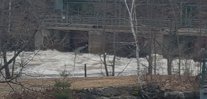
Last year the snowpack saturation level climbed to an extraordinary 250 percent by April 21, fueled by two heavy rains. This was followed by an unusual warm spell triggering a rapid melt. A perfect storm. Despite the efforts of the Ministry of Natural Resources and Forestry (the ‘MNRF’) to draw our rivers and lakes down to record low levels, the runoff far exceeded the capacity of the drainage system to handle it, and the Muskoka River reverted to what it had been for ten thousand years before the first dam was built—a ‘wild river’. Many of our lakes rose by over five feet from their drawdown lows, and flood waters reached well into downtown Huntsville.
We should have a much better sense of the flooding outlook this year by April 15.
But having experienced two ‘floods of the century’ in six years, it’s becoming clear to climate experts that dramatic spring runoff is the new normal. Trends suggest more 24-hour periods in January and February where the temperature does not dip below freezing. This means less ice cover and more open water in Georgian Bay to be picked up by the prevailing westerly wind and deposited as rain into the snow cover of Muskoka and Algonquin Park. So, we can expect higher saturation levels of the snowpack and greater runoff in spring.
Leaving spring flooding aside, what about water levels during the rest of the year? The MNRF manages our watershed. They operate some 29 dams and controls in an area roughly the size of Prince Edward Island, under the Muskoka River Water Management Plan (MRWMP). Huntsville is on the north branch of the Muskoka River, and our water levels are controlled primarily by dams above Lake Vernon, below Fairy Lake at the locks, and at Port Sydney. Most of the shoreline on the river and most of the lakes on the north branch is “soft”. Beaches, earthen banks, and the like. It is very vulnerable to erosion.
For over sixty years we had ‘water levels peace’, with practices governed by the Hackner-Holden Agreement of 1940. Beaches were substantial and shorelines pretty stable. Waterfront owners could enjoy their docks from May 24 to Thanksgiving. But the introduction of the Muskoka River Water Management Plan by the MNRF in 2006 changed all that. The plan called for higher water from June to mid-August annually, and lower water from then to late fall.
Anyone who has boated the stretch of the Muskoka River from the Brunel locks down to Mary Lake in the past couple of years will have seen the magnificent white pine tree that is now leaning precariously over the river. This forest king stood tall on the east bank for the better part of a hundred years until the softening of the bank and erosion under the MRWMP of 2006 began the inexorable process of toppling it. Hundreds of other lesser trees along that stretch of the river are suffering the same fate.
Many waterfront owners on the river and our lakes have seen their beaches diminished and shorelines ravaged by erosion. Some complain that their docks are under water well into June. The natural lakefront and riverfront environment which draws so many of us to this area is being diminished. The environmental case for a review of the MRWMP is strong.
In addition to the environmental case, there’s also a powerful economic case for a review of the MRWMP. The Huntsville and Port Sydney dams (and many others in Muskoka) were built around 1870 to serve the lumber industry. Lumbering was becoming a major driver of the Muskoka economy and water level control policy was designed to serve it. Today, the overwhelming economic benefit derived from our lakes and rivers is the economic activity around their use and enjoyment by permanent and seasonal residents. One might think it obvious that in Muskoka of all places we should be working overtime to avoid policies that might diminish that precious—and precarious—natural environment.
And of course the environmental and economic cases for review of the plan are augmented by the climate change case. The history of the last couple of decades, together with very disturbing climate forecasts, make a very compelling case to reopen the plan.
It’s important to understand that local MNRF staff who implement the MRWMP are good people who care about the environment. They are accessible and helpful. But they’ve been tasked by “head office” with administering a problematic plan.
The 2006 MRWMP was devised by an earlier provincial government that was determined to develop green energy, sometimes at great cost. Revised water levels might better serve hydro power stations on both the north and south branches of the Muskoka River. There is indeed evidence that that was the primary policy reason behind the 2006 plan.
Green energy is good. And in this era of climate change induced by human activity, we need more green energy. But must we trade off our natural environment—soft shorelines, fragile wetlands—and continue to turn cottage country into a power reservoir? There’s no evidence that we need to do that. Indeed, there’s a good case that hydro-electric power generation and respect for our natural shorelines can coexist. It’s just that power generation should not trump our environmental concerns.
There has been no meaningful public review of the MRWMP. An earlier provincial government promised to conduct a consultative review of the plan in 2016. No such review took place.
In August of last year, the Ontario Ministry of the Environment, Conservation, and Parks (interestingly, not the MNRF) established the Muskoka Watershed Advisory Group—a panel of nine volunteers chaired by the very able Mardi Witzel—whose mandate includes identifying “priority issues” in connection with the Muskoka Watershed. The group heard submissions in November in Port Carling from a number of interested parties and concerned lake associations, many of them calling for a review of the MRWMP. The advisory group’s report is expected in May.
It may be that their report will be the thin thread by which a review of the flawed 2006 Muskoka River Water Management Plan, and a return to a plan more in keeping with the needs of our precious waterfront environment, hangs.
Following a career in government and in business, Ted Johnson has retired to his Port Sydney home where he and his family make maple syrup and enjoy the outdoors. He is a director of the Mary Lake Association.
Don’t miss out on Doppler!
Sign up here to receive our email digest with links to our most recent stories.
Local news in your inbox three times per week!
An insightful article.. although having rented a property (temporarily) on the ‘Big East’ off Rivercove Dr.,
I was questioning why the focus was solely on the Muskoka River. There were numerous dams along
the Big East going back many years. I heard (from long term residents) that they were systematically
removed over many years.. who was responsible for that.. the MNR? The local (not so funny) joke with
long term property owners is.. ‘lovely spot, hope you don’t mind the swimming pool in your backyard,
OR your basement!’ Perhaps the author could provide some feedback, as to why the focus of the article
didn’t include those without million dollar properties on the Muskoka River? Just sayin’. Thanks.
A fact worth remembering is that in general, high water causes damage and costs and low water is just an inconvenience.
This said a lot depends on how high or low and when.
I only know about Lake of Bays but lately it seems that we get a greater than normal flood in spring and then in the late summer and fall the water is so low that I can’t use half my docks except for a canoe.
My memory says this did not always seem to be the case.
Lake of Bays cannot really “flood” as the dam has a huge spillway such that excursions of more than about 2 feet above normal are almost impossible to achieve. Hurricane Hazel did manage to exceed this.
Even so, high water can cause extensive damage, especially when combined with free floating ice like last spring. Without ice, erosion and dock damage is still significant.
I know it is a hard thing to control, hard to predict but when I think back we did not seem to have as many or as severe high water episodes as we do now, nor did we see such low water so early in the fall.
I have to agree that something has changed as Ted suggests.
As imperfect as it is, my memory tells me that we are having more frequent, longer duration and more extreme swings of weather over the last 60 years. We see the effects of this all year long but it is most apparent in the spring when a normal melt puts water levels close to maximum and a prolonged warm rain during the melt process can have disastrous results. So far 2020 is looking good, with a slow melt and some cool periods to check the flow but like many, to say I don’t fully trust our officials at the MNR would not be an understatement. Maybe they have too many bosses and the plan is indeed not a good one anymore.
Excellent point, Ms. Hogg: The most objective viewpoint is always that of a knowledgeable, volunteer group. They have no “skin in the game”; beyond the well-being of their constituency; the permanent and seasonal residents of Muskoka.
As part of my job (and a personal interest), I had a copy of the Hackner-Holden Agreement; containing hydrographs on all the relevant dams. It was a useful guide in designing culverts to handle the spring freshet. Having retired in 1995, I had no idea that it had been superseded (without fully considering all the consequences).
I agree, Mr. Johnson, that this year is shaping up very favourably to date. Nevertheless, one only has to extrapolate from the fact that 19 of the past 20 years have been the warmest on record, to suggest that (without some change) another historic flood is not too far off.
Globally, we have only 420 kilotons of CO2 discharge available for the next 8 years to prevent a temperature increase of 1.5 C degrees by 2100. Considering that the U.S. receives 44% of its energy from coal-fired plants, and that China builds a new one every week; this goal is not attainable. Saudi Arabia and Russia fighting an oil-price war to see who can virtually give their fossil fuels away further exacerbates the situation.
Whatever we do locally, unfortunately, will always be opposed by contradictory global forces. Historians may note that the climate crisis would have been significantly ameliorated; but for the election that Bush STOLE from Gore. Damnable chads!
Ted , the damage done by that action in 2006 still resonates.After a half century of hard work maintaining and protecting fragile clay shoreline banks , a government decision destroyed the efforts of family generations ! The denials by power authorities public and private were shameful. Thanks Ted for Your hard work on this .
Thank you, Ted, for a clear and comprehensive article on spring floods and water levels. I hope you provide another article in May following the report of the Watershed Advisory Group.
Elspeth Hogg
The way I see this is it’s going to be almost impossible to control the water and make everyone happy. once the water gets so high on any dam it has to be let go or the dam will break so when this happens you get flooding down river.
I have heard some say just get rid of all the dam’s and go back to nature the way it was but if we did that there would be a lot of water front homes that would not have water front anymore and in summer the river between our four lakes would likely be almost dry.
It’s sure going to be a hard thing to come up with a solution but just maybe they can do it time will tell I guess.