In 2023, Huntsville council instructed staff to explore how taller buildings and greater density could be accommodated within Huntsville’s urban core while still protecting cherished vistas.
With construction costs on the rise, many developers are seeking greater density and height to make their efforts worthwhile.
At the May 13, 2026, public portion of the Planning Council meeting, staff returned with their recommendations.
They’re proposing sweeping new rules governing taller and denser residential development as the Town looks to balance more housing with the protection of its natural landscape and scenic views.
The proposed changes are outlined in a draft height and density policy report and related proposed amendments to the Town’s Official Plan and Community Planning Permit Bylaw.
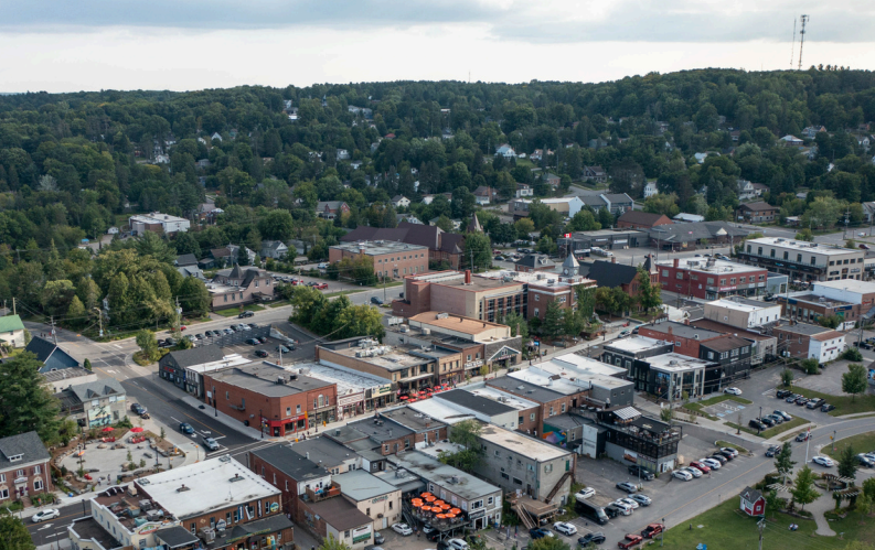
The framework would allow some residential and mixed-use developments within Huntsville’s urban settlement area to increase in height from the current maximum of 11 metres, or roughly three storeys, to up to 15 metres in designated “high suitability” areas.
Town staff said the changes are intended to support housing supply, rental housing and intensification, while ensuring new development fits with Huntsville’s character.
According to the report, staff were requested to develop criteria for reviewing mid-rise residential buildings in the urban settlement area, particularly purpose-built rental apartments. “The goal was to make sure these types of buildings, especially rental apartments, can be built without negatively affecting important views or the natural and urban character of the area,” it states.
To determine where taller buildings may be appropriate, staff created a “Suitability Map” ranking properties as having high, medium, low or no suitability for increased height and density.
The mapping considers factors such as topography, wetlands, significant wildlife habitat, steep slopes, proximity to parks and transit, and visibility from scenic viewpoints.
Highly suitable lands are generally located near existing built-up areas, parks, trails and bus stops, while also being less visible from important public viewpoints.
Properties within proposed “Hill Crown Overlay” areas would continue to face stricter limits, with no increase beyond 11 metres permitted in order to protect prominent hills and skylines, reads the report.
The proposal also introduces extensive design requirements for developments seeking additional height.
Buildings exceeding 11 metres or three storeys would be subject to new performance standards, including mandatory upper-storey step-backs, enhanced landscaping requirements, preservation of mature vegetation, restrictions on rooftop mechanical equipment, and additional amenity space requirements.
The report is also proposing stricter buffering standards between taller developments and neighbouring residential properties. Where existing vegetation is lacking, developers could be required to provide expanded landscaping and privacy fencing.
Parking areas would no longer be permitted between buildings and streets, while bicycle parking and amenity areas would become mandatory components of larger developments.
Mixed-use developments in some areas would also be required to maintain commercial uses on the ground floor to support active streetscapes.
A major component of the proposal focuses on protecting Huntsville’s views and natural character.
Staff identified 23 “Significant Views” through a public survey process and plans to require Landscape and Visual Impact Studies for developments seeking additional height. Those studies would evaluate whether proposed buildings could affect important views, ridgelines, or the surrounding landscape. However, provincial legislation, if passed, could prevent the municipality from adopting such requirements.
The proposed framework developed by Huntsville planning staff would also allow the Town to request community benefits in exchange for additional height or density approvals. Potential benefits could include affordable housing, public art, transit infrastructure, active transportation amenities, park improvements, sustainable building features, or cash contributions. However, it notes that high development costs and current market conditions continue to create financial challenges for builders, and staff say community benefit requirements may need to be applied flexibly.
The plan was presented by the Town’s senior planners, Madalene Albano and Kelsea Shadlock.
Just two people spoke at the public meeting. One, a former employee in the Town’s GIS department, Utterson resident Mark Flynn, who congratulated staff on the guide and said it’s a tool council will be able to use when faced with tough decisions.
He said the issue of increasing height and density is something impacting municipalities across Ontario, “and then we struggle with them. How to be progressive, to bring prosperity and growth to our communities, yet maintain the very reason why people are drawn to our community,” said Flynn. “This balancing act falls on our councillors, and these are tough decisions. You need a tool. I believe this proposal is one of those tools. I am in favour of this proposal,” said Flynn, who called it well-conceived, thoughtful, well-balanced and founded on strong geospatial analysis. “We have found the balance between progress and maintaining a rugged and majestic environment,” said Flynn.
The second speaker, seasonal resident Mark Boekelman, spoke about looking at the “big picture.” He asked the municipality to consider the development of brownfields and adopt a holistic approach to development rather than “piecemeal.” He said that with the return of the train, the population and tourism to Huntsville will grow.
Planning Chair Council Bob Stone told Boekelman that the municipality is “internally investigating the lands around the train station, and the comeback of the Northlander, so that’s already underway,” he said.
You can find the report HERE (PDF). Staff are expected to make amendments based on public consultations and further review, and return to the Planning Council.
Don’t miss out on Doppler!
Sign up here to receive our email digest with links to our most recent stories.
Local news in your inbox so you don’t miss anything!
Click here to support local news
Smeone needs to explain why we needx to destroy the touch and feel of Huntsville with higher buildings versus responsible planning. This council is destroying this town.
This is a council OUT OF CONTROL.First we get a muncipal chair who destroyed Barrie and not our Mayor(ex planning manager) and council has started to allow builders to continue to build crap apartments on main and Brunnel. This town is in real troble under this council. And just as an added comment Councillor Scott running mayor says he was instrumental in driving housing so the mess continues. Get rid of this council.
Bike parking? I guess town council should back that up with actual bike paths to allow safe travel on bike around the area.
Higher is NOT needed in Hutsville
What we really need is more parking