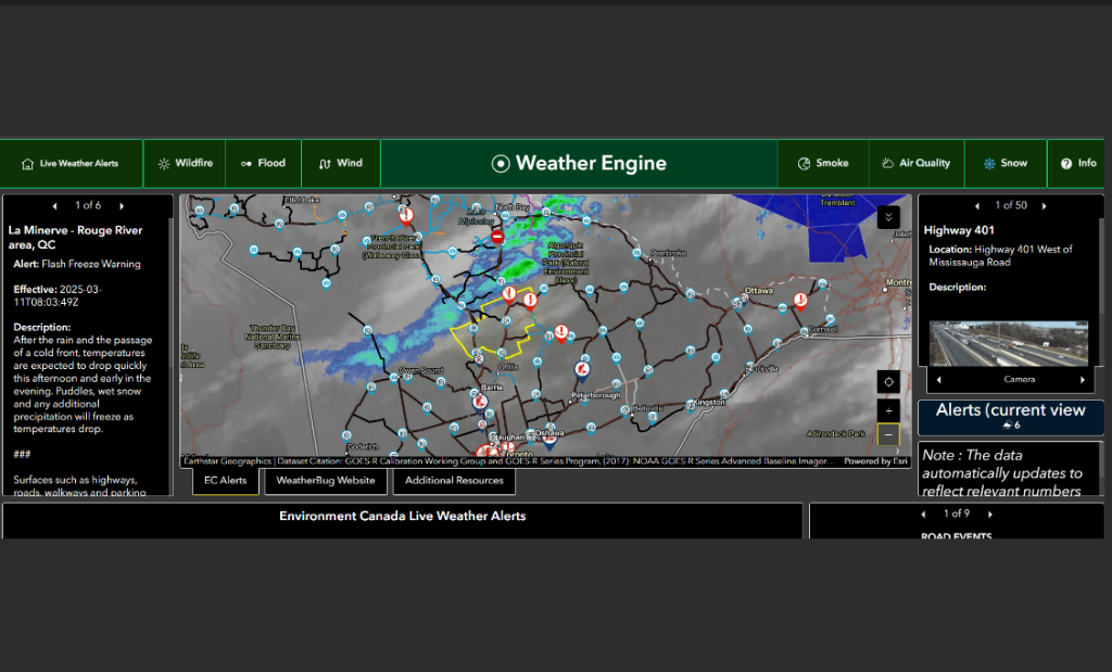
The Town of Huntsville and the Township of Lake of Bays have launched a new weather repository mapping system called The Weather Engine.
Developed by the municipalities’ shared services Geographic Information Systems (GIS) team, this innovative platform provides real-time environmental insights tailored to the region. By integrating multiple data sources into a single, user-friendly system, it empowers staff, residents, and citizen scientists to stay informed and take proactive measures to protect their properties and communities.
The Weather Engine simplifies access to critical environmental data by consolidating approximately 16 different data sources into one centralized platform. Instead of searching multiple websites or apps for weather alerts, flood risks, or air quality updates, users can find everything they need in one place. From monitoring local water levels and tracking snowfall to staying ahead of severe weather, this tool provides real-time insights to help residents and staff make informed decisions quickly and easily.
Key Features:
- Live Weather Alerts & Radar: Real-time updates from Environment Canada, including integrated radar imagery
- Wildfire Monitoring: Fire danger ratings and satellite data from NASA and NOAA to help track wildfire risks.
- Flood Monitoring: Local water levels, including Fairy Lake and Oxtongue River, with historical flood trends for better planning.
- Air Quality & Smoke Forecasts: Current air quality conditions and predictive insights to help residents plan their activities.
- Snow Cover & Forecasts: Real-time snowfall data, predictions, and water content for better winter and spring preparedness.
The Weather Engine integrates and displays interconnected environmental data in real time and the interactive map updates dynamically. This allows users to zoom in for local details or pan out for a broader Muskoka-wide view.
“This tool is an essential resource for both municipal staff and residents,” said Jose Augustine, GIS Technician. “It supports road operations, aids emergency response teams, and helps property owners assess environmental risks by providing critical data in a single, streamlined platform.”
By integrating multiple public datasets into a one-window system, the Weather Engine enables a proactive approach to environmental awareness and safety. The system provides valuable insights for residents, municipal teams, and climate-engaged citizens to stay informed and make data-driven decisions.
To explore The Weather Engine and start using its real-time insights, visit Huntsville.ca.
Don’t miss out on Doppler!
Sign up here to receive our email digest with links to our most recent stories.
Local news in your inbox so you don’t miss anything!
Click here to support local news
–
This is a great tool for data nerds like me! Everything at one place! I was reading through the comments and here are my thoughts: I think every map has a little arrow that opens some options, and one of them is the legend. Also, zooming in and out updates the data, so if you’re checking out a specific area, try zooming in—it should narrow things down, works for alerts too! Not sure about the comments regarding the road/place name error.
I went and tried this out.
Lots of errors in the maps. Mostly road and place names and positions.
I remain to be convinced that this is significantly better than the Environment Canada weather site. One thing to remember about weather is that it is neither made or driven locally. It usually arrives from the westerly direction and is driven by the events over thousands of miles in that direction. When it actually gets to Muskoka there is little in the way of driving forces that effect it. The exception to this is summer thunderstorms and these things are often very local. Unfortunately they are often very random too and predicting them is more a case of statistical odds than anything else. Once they exist then they can be tracked locally and maybe this new application will work well for this if enough data can be input rapidly enough to actually keep the site current to real time. This could be no small task on an event filled summer day but I live in hope for this type of service.
Taking a look at the overall weather from Environment Canada’s site and looking up at the sky still works well for me.
I took a moment to look at the planning map too. It is not that helpful as there must be a legend for all the markings on it somewhere but it is not an obvious find.
Again, a lot of small road and place name errors. For one example, Lumina Resort, a fairly sizeable place has jumped a mile or so down the lake from where it actually is.
Considering the detail that LOB likes in planning, errors of this size call into question the value of the map for anything. I mean how do you know if the features shown are really where they say they are when you see obvious errors in your local area at a first glance.
I think there is more work to be done in this field before these kind of sites are trustworthy enough to be really useful.
Interesting.
Will be looking here as the spring and summer unravel.
I didn’t see symbol explanations / Legend Key.?