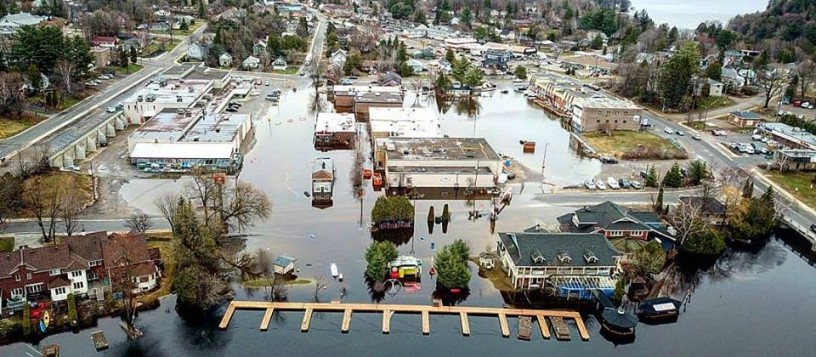
After hearing from hundreds of concerned residents, District councillors have hit the pause button on a key piece of its long-term environmental planning strategy, delaying the adoption of updated floodplain mapping to allow for more public consultation.
The recent decision by the District’s Planning Services Committee comes as flood-related concerns continue to dominate conversations across Muskoka, where several councillors acknowledged that high-water events have become increasingly severe in recent years.
During debate on Official Plan Amendment (OPA) 61, staff emphasized that the proposed floodplain mapping would not alter lake levels or change how water is managed throughout the watershed. Instead, the maps are intended to identify areas at risk of flooding and guide future development decisions.
However, public reaction to the proposal has been significant.
Mayor Peter Kelly noted that flooding has become “much, much worse in the past 10 years,” while District staff explained that the Muskoka River Water Management Plan regulates water flows but cannot eliminate flooding altogether.
Councillor Don Smith argued that moving ahead immediately could reduce pressure on the Province to review water management practices. He successfully introduced an amendment to defer the floodplain mapping component, allowing time for additional public engagement and continued advocacy with provincial officials.
Councillor Mike Peppard stressed that the proposed policies would not prevent property owners from building on their land.
“This doesn’t say you can’t build,” he said. “It just says you need to build properly.”
Council ultimately approved the broader Environmental Resiliency component of OPA 61 but removed the sections dealing specifically with floodplain mapping. Updated LiDAR-based floodplain maps for Lake Muskoka, Georgian Bay and other waterbodies were also excluded from immediate adoption.
District staff have been directed to prepare public information materials and host an additional consultation session before bringing the matter back to council. A report summarizing feedback is expected at a joint committee meeting in September.
The floodplain mapping initiative forms part of a broader environmental resiliency strategy that has been more than eight years in the making. Developed through extensive technical studies and provincially funded watershed projects, the plan aims to strengthen flood resilience, modernize natural hazard policies and provide consistent mapping standards across Muskoka.
Public concerns raised during consultations this spring focused largely on the potential impacts of the mapping and renewed calls for a review of the Muskoka River Water Management Plan. District officials maintain that changes to the provincial water management system would not significantly alter the extent of the mapped floodplain.
For now, council’s decision means residents will have another opportunity to weigh in before the controversial mapping returns for consideration later this year.
Don’t miss out on Doppler!
Sign up here to receive our email digest with links to our most recent stories.
Local news in your inbox so you don’t miss anything!
Click here to support local news
If we, as Canadians and local Huntsville residents got together and got the proper repairs to the water shed dams and infrastructure that protected us for so many years the issues would be much less. They spin this as environmental issues growing, when in fact it is a lack of integrity in the maintenance of critical infrastructure.