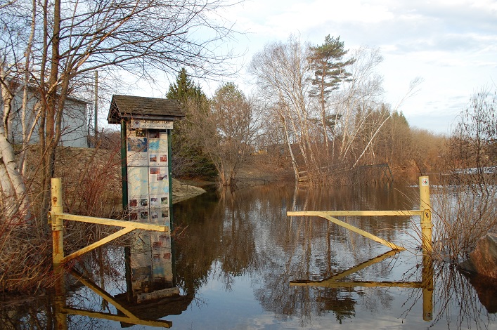
UPDATE April 23, 2019, 4:30 p.m. Today Mayor Scott Aitchison issued a statement regarding rising waters and the Town of Huntsville released additional information for residents. You can see details and a video of Mayor Aitchison’s press conference here: Flood update for Huntsville and statement by Mayor Scott Aitchison (video)
Snow melt and rain have caused flooding in low-lying areas in recent days. Current road closures, as of the afternoon of April 22, include:
1. Full road closure in effect on Ravenscliffe Road at North Fox Lake Road and #4198 due to flooding. A detour is routing traffic to Stisted Road South to Highway #518 through Sprucedale.
2. The full road closure is still in effect on Ravenscliffe Road at Tipper Lane and Rowan Drive; crews are onsite repairing damage. Traffic from this earlier closure on Ravenscliffe is being routed through Muskoka Road 45 Hoodstown / Etwell Road.
3. South Drive is closed due to flooding.
4. Bayshore Blvd. is closed from #700 to West Airport due to flooding.
5. John Street is closed from Manominee St to Main St due to flooding
6. Cann Street is closed from John Street to Freshco due to flooding
7. Silver Sands Road is closed before Silver Sands Park due to flooding
8. Glen Acres Road is closed due to flooding
9. North Ceramic Mine Road is closed at the bridge due to flooding/washout
10. Old North Road is closed from Silver Sands Rd to Fowlers Rd
11. Skyhills Road at #536 is closed for repairs due to flooding
12. Doppler readers also report that Hwy 592 is closed in Emsdale at the Little Big East River due to flooding.
If you are aware of other closures, please leave a comment below.
The photos and video below show some of the flooding and subsequent damage and repairs. If you have photos from other areas, send them to us at [email protected].
Andrew Galbraith submitted the video below (captured on April 21, 2019) from Ravenscliffe Road near Rowan Road where rushing water undermined the road and caused part of it to collapse. Crews have dug down to repair the damage.
The Muskoka River crested the Town Dock on Saturday, April 20 as shown in the first three photos below taken on the morning of Sunday, April 21. By the morning of Monday, April 22 (final two photos), it had begun to encroach on Dara Howell Way and the patio at Boston Pizza, and by the morning of April 23 had advanced still further.
- April 21, 2019 At the Town Dock by On the Docks Pub
- April 21, 2019 Town Dock with Boston Pizza across the river
- April 21, 2019 Muskoka River and Town Dock from the swing bridge
- April 22, 2019 Muskoka River at Town Docks
- April 22, 2019 Dara Howell Way

On the other side of the river, parts of John Street and Cann Street were closed due to flooding. These photos were taken on April 22.
- April 22, 2019 a.m. Cann StreetApril 22, 2019 Cann Street
- April 22, 2019, in the a.m. Intersection of Cann and John Streets
- April 22, 2019 a.m. Water flowing over John Street
- April 22, 2019 p.m. Boston Pizza parking lot next to John Street
- The Muskoka River crested its bank and spread through the intersection of John Street and Cann Street. This photo was taken the afternoon of April 22.
- Businesses half way up Cann Street between John and Chaffey have been affected
- April 22, 2019 p.m. Cann Street
Further upstream, the Hunters Bay Trail trailhead beside Centre Street North was under water.

In other parts of town, roads were flooded or washed out, causing long detours for some residents. On Ceramic Mine Road North, residents of seven homes past the bridge have been unable to leave by vehicle since April 19 when the water overran the bridge and washed out part of the road. Today, crews added some rock to help stem the flow, and residents added boards so that they could get across the worst of the current. The photos below were submitted by Blythe Presley.
Silver Sands Road, off Old North Road near the intersection of Highway 11 and Muskoka Road 3 North appears to taper to nothing due to flood waters.

Another section of Ravenscliffe Road was closed due to flooding. Doppler reader Tamara Bernier Evans shared these images and added, “It would be great if folks could refrain from driving through blocked areas as the wake is threatening to cause flooding in my house. It’s that close!”
- April 23, 2019 Ravenscliffe Road near south end of Buck Lake (Photo: Tamara Bernier Evans)
- This property on Ravenscliffe Road near the south end of Buck Lake is one of many affected by flooding (Photo: Tamara Bernier Evans)
Stay tuned for further updates. With water flows dropping (the water flow peaked on the Big East River at Williamsport on April 20), water should begin to recede in Huntsville’s core but areas further downstream may still see waters rise.
Don’t miss out on Doppler! Sign up for our free newsletter here.


Just wondering if there’s any flooding from Buck Lake on Patricia Ave.
Roma Boiko
Hwy 592 is closed in emsdale at little big east river due to flooding.