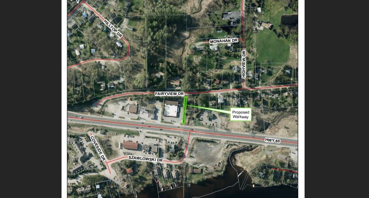
In the October council meeting, Huntsville Council approved a proposal from Town staff to enter into an agreement with a property owner on Highway 60 to use a portion of the property to establish a Town-maintained walkway for the upcoming winter. This walkway will connect Fairyview Drive with the pedestrian crossing at Highway 60 and Szawlowski Drive, keeping pedestrians safe and connected to the community during the winter months.
“Thanks to the collaboration with a private property owner, we are happy to announce a Town-maintained walking path to help residents cross Highway 60 safely this winter,” shares Mayor Nancy Alcock. “Huntsville is an active community – and that doesn’t stop once the snow flies. We are working to build on this initiative to increase resident’s year-round connectivity in the community.”
Town staff are working to find a more permanent solution to connect the Town’s active transportation routes from Fairyview Drive, across Highway 60, and to downtown Huntsville. These efforts are in response to community feedback requesting a review of pedestrian safety in the area.
This new walkway will divert pedestrian traffic away from the paved shoulders on Highway 60. Throughout the winter, these paved shoulders are used by the Ministry of Transportation Ontario for snow storage and are filled with snowbanks, making them unsafe for pedestrians use.
Don’t miss out on Doppler!
Sign up here to receive our email digest with links to our most recent stories.
Local news in your inbox three times per week!
Click here to support local news
Brian, we have added a map.
I am so thrilled that our efforts are being brought to fruition albeit temporary.
Suzanne Treadwell
I wish there was some real detail in this article. Crossing Highway 60 and Szawlowski Drive is a lovely idea, especially since it already exists. But practically, how does one actually get there? Down the slope from Fairyview, rather than along the highway? and then where do you go? Wind your way through Rogers Cove and across through Muskoka Landing? I have a hard time visualizing the route, and a harder time believing it will be either convenient or safe.
Thank you Nancy and Kathy for mentioning Ravenscliffe and Aspdin Hwy 11 crossings. I have long thought that safe passages need to be made in both places for pedestrians and cyclists. Its not unusual to see public school age children crossing Ravenscliffe at the Hwy 11 bridge both on foot and cycling.
In stories like this it sure would be handy to include some kind of map, even just a hand drawn sketch, so that someone could sort of visualize where the new walkway actually is.
This is great news! Looking forward to seeing the map and quickly finished pathway with dedicated snow removal too!
Nancy Long, I too was disappointed that Aspdin Road and Ravenscliffe plus Muskoka Rd 3N weren’t made more safe for pedestrians or cyclists, especially as pavement was being refreshed anyway. I appreciate it’s not inexpensive, but still a lost opportunity!
I hope the town is looking at active transportation routes out Aspdin to Etwell, through to Hoodstown and back to town via Ravenscliffe. It would be great if there was a dedicated biking/walking path for people to use, and not have to share the road with vehicles. On this note, the widening of Aspdin just wasn’t sufficient to feel safe while biking or walking. We need better!
While visiting other tourist communities, like the Laurentians, it is nice to see these types of paths being used.