From the MNR
The Ministry of Natural Resources – Bracebridge-Minden-Parry Sound District is advising area residents that a Watershed Conditions Statement – Flood Outlook Bulletin is in effect for the district until Friday, July 19, 2024.
This message is intended for residents and visitors within the MNR Bracebridge-Minden-Parry Sound District for portions of the District of Parry Sound, District of Muskoka, County of Haliburton, and City of Kawartha Lakes within the Black, Burnt, Gull, Magnetawan, Muskoka, Pickerel, Seguin, and Severn River Watersheds.
Hurricane Beryl made landfall along the Texas coast of the USA on July 8 and has significantly weakened after landfall. While moving northeast and towards the Lower Great Lakes, remnants of Beryl are forecast to merge with an upper trough that is currently over central North America, creating a highly efficient conveyor belt of moisture into southern Ontario.
The remnants of Hurricane Beryl reached Ontario on the evening of July 9. It is forecasted that this may result in significant precipitation into the southern portion of the province over the next few days. Confidence on the exact path of the system is low.
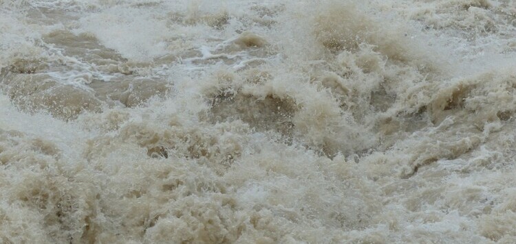
The MNR Surface Water Monitoring Centre (SWMC) updated the Provincial Flood Watch on July 10 and indicated that the areas at greatest risk of the heaviest rainfall are situated immediately south of Georgian Bay and along the St. Lawrence River. These areas could receive 50-100mm of total rainfall from this event.
Lower-lying portions of known flood-prone areas may be impacted to varying degrees as lake/river levels rise in response to received precipitation. Residents and visitors should exercise caution while around waterbodies and maintain close supervision of children and pets.
MNR also advises extreme caution when using forest access roads for outdoor activities as they may become seasonally inundated with water, are prone to washouts and may become impassible due to localized flooding.
Residents who have been affected by high water and flow conditions in the past should continue to take necessary action to protect/secure any vulnerable property in proximity to rivers and lakes, closely monitor developing conditions, and regularly check for updated messages.
The ministry is closely monitoring the weather and developing watershed conditions. Further updates will be issued as appropriate.
TECHNICAL INFORMATION
Description of Weather System
Environment Canada Issued a Rainfall Warning for the Muskoka-Parry Sound area on July 9 at 2:00pm. Rainfall with embedded torrential downpours expected.
Rainfall totals of 40 to 60 mm, with locally higher amounts are possible. There is a potential for torrential downpours with rainfall rates of 20 to 40 mm per hour at times.
Rainfall in the area started on the evening of July 9 and is forecasted to continue through to the morning of July 11. The heaviest rain is anticipated to occur on July 10 into the evening.
Rainfall amounts are expected to be highly variable across the region, and some areas may receive in excess of 60 mm. Rain is forecasted to taper to scattered showers from west to east tonight through the early morning of July 11.
Description of Current Conditions
MNR has conducted proactive dam operations across all watersheds in the Bracebridge-Minden-Parry Sound District to increase flows.
Prior to the Beryl weather system, water levels on most major lakes were trending down and within the Normal Operating Zone (NOZ) for this time of year. However, should significant precipitation be received, water levels may rise outside of the NOZ.
River flows are currently higher than average for this time of year due to previous significant rainfall. River flows are anticipated to increase further as additional precipitation is received and dams are operated to mitigate to the extent possible against high water.
The watersheds are complex cascading systems: water inputs received upstream must travel down through the watershed before exiting the system and permitting water levels to return to the NOZ. This means that water levels and river flows for locations near the bottom of the watersheds can remain elevated for longer periods of time while the additional water works its way through system.
Don’t miss out on Doppler!
Sign up here to receive our email digest with links to our most recent stories.
Local news in your inbox so you don’t miss anything!
Click here to support local news
Pretty humbling to know that indigenous people ran the watershed for over a hundred years without the problem of flooding! Is someone winking at me right now?
If the last Canadian ice sheets were receding about 11,000 years ago, and if eastern Asiatic people were crossing to America up to that time, those indigenous peoples had the run of the show for a whole bunch of time over 12,000 years. I can imagine the only thing that carried out any kind of dam building and water control back then was the beaver. And for sure they can cause flooding.
People, both indigenous and the rest of us have suffered flooding. The epic of Gilgamesh speaks of a flood when the god Enlil decided to destroy the people ’cause they were too noisy. And the Genesis flood appears in the story of all three Abrahamic religions. Apparently the noise was still pretty bad.
In our area The Big East River Improvement Company built dams to cause controlled floods and create high water on local watersheds. They would open the flood dams to ‘river- run’ the winters cut of logs to the lakes. The Lands and Forests bought the New Big East River Improvement from the last owner and proceeded to build ‘control dams’ on local rivers. The Big East got Distress Dam, Finlayson and other dams on the upper watershed.
Few of these dams are operated for flood control anymore. Distress is a fixed barrier dam and Finlayson was broken up and buried in the forest. McCraney Lake still has a dam, and when I was younger, driving to the landing, camping out, and fishing for lake trout was a treat. ‘Though it always meant for a couple of long days. And sometimes the bugs!!!!
One particular flood I do remember was in 1954 after Hurricane Hazel. It was thought that the water was going to sweep away the bridge on the highway. Dad and Mom loaded us kids and we drove up to have a look. Most of the town was there, plus everybody from north of town. The police busy keeping people from getting in too close. The valley was full of water and you could hear the water chugging and roaring in the beams beneath the bridge. The entire structure was humming.
Mother Nature started it and no one was going to make it stop. ‘Not ’til she and God had reached an understanding.
And we never lost the bridge.
Well, from my viewing point, one could say that “Beryl was a bust”. A day or drizzle, not much worse than listening to some politician on the evening news.
Today was supposed to be so wet we’d need web feet but it was hot, very hot, dry, sunny, the exact opposite of what we were told to expect.
Oh well…. they tried.
Nuts – why the watershed complication? – for over ahundred years the Indigineous community ran the watershed and NEVER had floods as they proacted not reacted and didnt hv layers of useless beauocrats and 6 companies in 2 provinces involved
That all changed in 2013 with MNR taking “control” with graphs and algorythmns all from queens park – flooding ever since and boy 2017 took the cake
Yes there was high waters but NEVER flooding – again such a farce and more damaged property with NO ACCOUNTABILITY